
The Inner West Council will vote in early March 2024 on the rezoning – we need you to let Councillors know the community is against this plan.
Go to our Take Action page to learn more about how you can help.
The majority of the Taveners Hill North precinct proposed to be rezoned from R1 to R3 is a flood zone. Some of our streets have a topography to be lower at the back of the property than the council footpath. For instance, in Kegworth street (south side of the street), some properties have a 1.5 to 2.0 metre difference. In effect, it would be difficult to use this land, hence the design decision to have a 6 metre build exclusion for some properties.
Impact on development
The main impacts are:
- Basement parking becomes an issue due to the topography of the precinct, for example Kegworth street slopes downward from East towards West. The bottom end of the street has significant flooding.
- Increased development costs to manage storm water via water traps and pumps in the basement car park.
- Hard landscaping for apartment blocks reduces the absorption of storm water run-off. The majority of existing dwellings targeted for demolition have gardens in both the front and back which absorbs excess water and reduces the overall “heat pockets” that higher density dwelling solutions create.
- More incentive for developers to offer lower purchase prices to optimise their profits.
IWC places the responsibility for managing storm water appropriately as part of the Development Application (DA) approval process.
Based on anecdotal information, on Tebbutt Street the overland flow of existing stormwater drainage network is under capacity for frequent rainfall events. Under existing conditions water flows west between properties regularly during rainfall events.
Areas to be confirmed
On review of the Appendix 5 Flood Impact Report by WMS, it appears that has WMS have assumed that all buildings are above flood levels, which we believe isn’t the case. In the case of Area 1 Taverners Hill Precinct (north of Parramatta Road and also knows as West Leichhardt) the following regarding flooding information for existing conditions is not specified and should be provided on:
1. Critical durations – be detailed to identified and mapped as to which specific site locations within Area 1 selected and why, setting out the Maximum Flood depth (m) for 5%AEP, 1% AEP, 1% AEP Climate change and 1% AEP Blockage.
2. Confirm floor level survey has been completed for properties within the flood envelope (typically the 1% AEP) (we believe the mapping looks like it has been assumed buildings are above flood level).
3. We request flood model is independently verified/reviewed by a suitably qualified person (CPEng NER).
What makes a bad development site?
As per “PMP_8-Tips-for-finding-property-dev-sites-1.pdf (propertymastermind.com.au)”, there was a statement on “UNDERSTAND WHAT MAKES A BAD DEVELOPMENT SITE”.
“It’s crucial to identify what makes a good development site, but it’s just as important to be able to identify what makes a bad one. Here’s a list of the things you need to examine:
- Flooding. It doesn’t necessarily mean that you can’t develop areas that experience flooding, but it does mean that the cost of development could be a bit higher.
- A site too close to the train tracks. To clarify, being close to the train station is good. But close to the train tracks is another thing.
- Slopy sites. Just because it costs more to develop properties on such sites/areas. You can’t get more profit from them unless you get a reduction on the land value.”
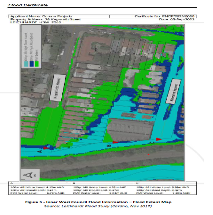
Flood Zones and level of flooding
The green shaded area on the map below shows the more significant flooding.
Supporting Documents
Read the Lungs Of Leichhardt Submission to Council
For more information on this and other issues, see the Lungs of Leichhardt community group’s full submission to the Inner West Council.